Rogers Dry Lake
| Rogers Dry Lake | |
|---|---|
 Rogers (center) and Rosamond (lower left) dry lakebeds in Mojave Desert, California | |
| Location | Mojave Desert Kern County, California Los Angeles County, California |
| Coordinates | 34°55′19″N 117°49′39″W / 34.921944°N 117.8275°W / 34.921944; -117.8275 |
| Lake type | Endorheic basin |
Basin countries | United States |
| Max. length | 19 km (12 mi) |
| Max. width | 11 km (6.8 mi) |
| Surface area | 112 km2 (43 sq mi) |
| Shore length1 | 61 km (38 mi) |
| Surface elevation | 694 m (2,277 ft) |
| Settlements | Edwards Air Force Base |
| References | U.S. Geological Survey Geographic Names Information System: Rogers Dry Lake |
Rogers Dry Lake Edwards Air Force Base | |
U.S. National Register of Historic Places | |
U.S. National Historic Landmark | |
 | |
| Location | Mojave Desert Kern County, California |
| Coordinates | 34°55′19″N 117°49′39″W / 34.92194°N 117.82750°W / 34.92194; -117.82750Coordinates: 34°55′19″N 117°49′39″W / 34.92194°N 117.82750°W / 34.92194; -117.82750 |
| Built | 1933[2] |
| NRHP reference # | 85002816[1] |
| Significant dates | |
| Added to NRHP | 03 October 1985 |
| Designated NHL | 03 October 1985[3] |
1 Shore length is not a well-defined measure. | |
Rogers Dry Lake is an endorheic desert salt pan in the Mojave Desert of Kern County, California. The lake derives its name from the Anglicization from the Spanish name, Rodriguez Dry Lake.[4] It is the central part of Edwards Air Force Base as its hard surface provides a natural extension to the paved runways. It was formerly known as Muroc Dry Lake.
Contents
1 Geology
2 History
2.1 Edwards Air Force Base
3 See also
4 References
5 External links
Geology
Rogers Dry Lake is located in the Antelope Valley, about 100 miles (160 km) northeast of Los Angeles. It covers an area of about 65 square miles (170 km2) at the low point of the valley, forming a rough figure eight. It is the bed of a lake that formed roughly 2.5 million years ago, in the Pleistocene. It is 12.5 miles (20.1 km) long at and 5.5 miles (8.9 km) wide at its greatest dimensions. The bed of the lake is unusually hard, capable of withstanding as much as 250 psi without cracking. This is sufficient to allow even the heaviest aircraft to safely land on it.[5]
During the extremely brief rainy season, it is possible for there to be standing water on the lakebed, which pools at the approximate low-point elevation of 2,300 ft for the region. The lake is adjacent to the smaller Rosamond Lake which through the Holocene, together made up one large water-body.[6]
History
The area of the lakebed was first used by the railroads, with a watering station for steam engines located nearby by the Atchison, Topeka and Santa Fe Railroad. In 1910, the Corum family settled on the lake bed; they attempted to create a small community called "Muroc" (the name reversed), which failed. In 1933, the United States Army arrived, looking to establish a bombing range in the area. The lakebed's potential use as an airfield was then realized, and in 1937 the United States Army Air Corps set up Muroc Air Field for training and testing, which later became Edwards Air Force Base.[5]
During World War II, a 650 feet (200 m) replica of a Japanese cruiser was constructed on the lakebed, nicknamed "Muroc Maru". The ship was demolished in 1950.[7]
Edwards Air Force Base
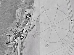
Many of the United States' notable aeronautical achievements have taken place at Rogers Lake, including the testing of experimental military aircraft, the breaking of the sound barrier by Chuck Yeager, and landings of the Space Shuttle.[5] It is also famous for the world's largest compass rose painted into the lakebed. It was designated a National Historic Landmark in 1985.[3]
Its principal runway is 04/22. In addition to its paved component of 15,000 ft (4,600 m) has an extra 9,000 ft (2,700 m) of lakebed runway, and is capable of landing all known aircraft.
There are seven other official runways on the Rogers lakebed:
- 17/35 is 7.5 mi (12.1 km) (primary runway)
- 05/23 is 5.2 mi (8.4 km)
- 06/24 is 1.4 mi (2.3 km)
- 07/25 is 4.0 mi (6.4 km)
- 09/27 is 2.0 mi (3.2 km)
- 30 is 2.0 mi (3.2 km) (runway 30 rolls out onto the compass rose, so its corresponding, unmarked, runway 12 is never used)
- 15/33 is 6.2 mi (10.0 km)
- 18/36 is 4.5 mi (7.2 km)
See also
- List of lakes in California
- List of National Historic Landmarks in California
References
^ National Park Service (2008-04-15). "National Register Information System". National Register of Historic Places. National Park Service..mw-parser-output cite.citation{font-style:inherit}.mw-parser-output .citation q{quotes:"""""""'""'"}.mw-parser-output .citation .cs1-lock-free a{background:url("//upload.wikimedia.org/wikipedia/commons/thumb/6/65/Lock-green.svg/9px-Lock-green.svg.png")no-repeat;background-position:right .1em center}.mw-parser-output .citation .cs1-lock-limited a,.mw-parser-output .citation .cs1-lock-registration a{background:url("//upload.wikimedia.org/wikipedia/commons/thumb/d/d6/Lock-gray-alt-2.svg/9px-Lock-gray-alt-2.svg.png")no-repeat;background-position:right .1em center}.mw-parser-output .citation .cs1-lock-subscription a{background:url("//upload.wikimedia.org/wikipedia/commons/thumb/a/aa/Lock-red-alt-2.svg/9px-Lock-red-alt-2.svg.png")no-repeat;background-position:right .1em center}.mw-parser-output .cs1-subscription,.mw-parser-output .cs1-registration{color:#555}.mw-parser-output .cs1-subscription span,.mw-parser-output .cs1-registration span{border-bottom:1px dotted;cursor:help}.mw-parser-output .cs1-ws-icon a{background:url("//upload.wikimedia.org/wikipedia/commons/thumb/4/4c/Wikisource-logo.svg/12px-Wikisource-logo.svg.png")no-repeat;background-position:right .1em center}.mw-parser-output code.cs1-code{color:inherit;background:inherit;border:inherit;padding:inherit}.mw-parser-output .cs1-hidden-error{display:none;font-size:100%}.mw-parser-output .cs1-visible-error{font-size:100%}.mw-parser-output .cs1-maint{display:none;color:#33aa33;margin-left:0.3em}.mw-parser-output .cs1-subscription,.mw-parser-output .cs1-registration,.mw-parser-output .cs1-format{font-size:95%}.mw-parser-output .cs1-kern-left,.mw-parser-output .cs1-kern-wl-left{padding-left:0.2em}.mw-parser-output .cs1-kern-right,.mw-parser-output .cs1-kern-wl-right{padding-right:0.2em}
^ Johnstone, Robert (January 16, 1986). "Muroc (Rogers) Dry Lake" (pdf). National Register of Historic Places - Inventory Nomination Form. National Park Service. Retrieved 20 May 2012.
^ ab NHL Summary Archived 2008-12-04 at the Wayback Machine
^ Public Affairs (25 July 2006). "About Edwards: History: The Dry Lake Beds". Edwards Air Force Base. Archived from the original on 2006-12-07. Retrieved 2009-09-10.
^ abc "NHL nomination for Rogers Dry Lake". National Park Service. Retrieved 2018-02-07.
^ Reheis, Marith C.; Hershler, Robert; Miller, David M. (2008). Late Cenozoic Drainage History of the Southwestern Great Basin and Lower Colorado River Region: Geologic and Biotic Perspectives. Boulder, Colorado: Geological Society of America. pp. 273–275. ISBN 978-0-8137-2439-3. Retrieved 2009-09-05.
^ "Rogers Dry Lake". National Park Service. Retrieved 2017-12-01.
External links
| Wikimedia Commons has media related to position. |
- Official Edwards Air Force Base website
U.S. National Register of Historic Places | |
|---|---|
| Topics |
|
| Lists by state |
|
| Lists by insular areas |
|
| Lists by associated state |
|
| Other areas |
|
| |


